
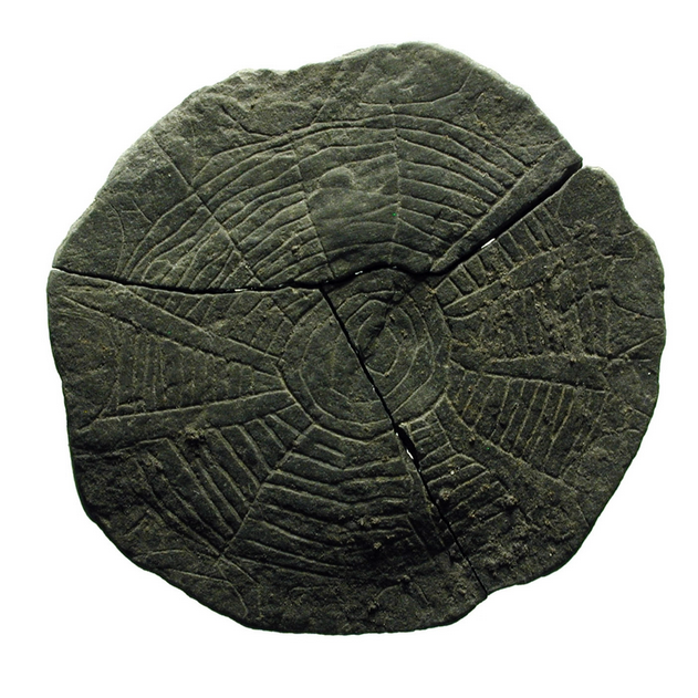
 This etched stone, found in 2016 with nine others at a 5,000-year-old sacred site in Denmark, may be a map. Archaeologists believe it is a symbolic representation of a local area, showing fields, fences and plants, and that it may have been used in Neolithic magic rituals designed to influence the sun and increase the fertility of crops. See more here.
Welcome to corvusfugit.com!
Corvus fugit means "the crow flies."-
Join 417 other subscribers
Recent Top Posts
- 1930: Work Must Not Cease
- 1573: The Inquisition Grills an Artist for the Last Supper
- 1883: Educate! Agitate! Organize!
- 1st Century AD: You Aren't Even Sure What This Is at First
- 1505: The Dog Hidden Under the Hidden Unicorn
- 206 BC: The Jade Suit of Liu Sheng
- 1927: Pancho Villa's Pet Deer Moves to Los Angeles
- 1793: Cards for Equality
- 1910: Streetcar
- 1828: Sala Dante
Blogroll
Tags
- 1860's
- 1870's
- 1880's
- 1890's
- 1900's
- 1910's
- 1920's
- 1930's
- 1940's
- 1950's
- 1960's
- 1970's
- 2000's
- 2010's
- Africa
- African-Americans
- Animals
- Art
- Belgium
- Birds
- Books
- Children
- Christianity
- Drawing
- France
- Germany
- Great Britain
- Italy
- Labor
- Landscapes
- LGBTQ
- Mammals
- Miniatures
- Netherlands
- New York City
- Painting
- Photography
- Poetry
- Portraits
- Printmaking
- Religion
- Science Fiction
- Sculpture
- Seascapes
- Ships & Sailing
- The Sky
- Trees
- Unions
- USA
- Women


It’s a depiction of a spider’s web possibly…
LikeLike
Or that 🙂
LikeLike